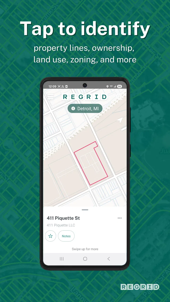
Regrid Property App
- 4.7
- Rating
- 500.00K
- Installs
- Free
- Price

 Analysis by App-foxy
I find property research much easier when I can see the land itself instead of trying to piece together scattered public records, street names, and map layers. Regrid Property is built for that specific job. It is a free Maps & Navigation app from Regrid that puts parcel boundaries, ownership details, acreage, land use, and zoning information into a map-focused experience. After spending time with it, I see it as a practical research tool rather than a general navigation replacement.
The app is especially useful when I want to understand how a piece of land is divided, where one parcel ends, or what kind of information is associated with a property. It can help with early research before a purchase, checking land near a home, planning a visit, or simply making sense of a rural area where ordinary map apps show very little beyond roads and terrain. Its value comes from combining location and property context in one place.
That focus also explains its limits. I would not use it as my only source for a legal boundary decision, a final zoning interpretation, or a transaction involving serious money. Property records can require local confirmation, and a map view is not the same thing as a survey or official legal document. Used with that understanding, Regrid Property is a strong first-stop research app for people who need parcel information without immediately opening a desktop database.
You May Also Like

 Blood Strike: 2.5 Anniversary
Blood Strike’s Loadouts Turn Every Drop Into a Tactical Gamble
A close look at Blood Strike’s custom loadouts: how fast access to signature weapons reshapes its battle royale rhythm, rewards preparation, and narrows the gap between fights.

 Pandora - Music & Podcasts
Pandora’s Music Is Easy to Start, but Harder to Recover
Pandora’s strength is its low-effort path from a seed to a station. Its weak spot is how much confidence it asks you to place in connection, setup, and quiet recovery.

 8 Ball Pool
 Is Built on Rivalries, Rematches, and Routine
A close look at the rivalries, rematches, shared routines, and unanswered safety questions that turn a quick pool match into a persistent mobile community.

 Samsung Music
’s Quiet Strength Is Playing What You Already Own
Its reach comes less from spectacle than from dependable access to a personal library. That simplicity is both the app’s strongest retention engine and its ceiling.

 AccuWeather: Weather Radar
AccuWeather Review: A Quick, Clear Forecast for Everyday Decisions
For everyday plans, the best forecast is the one you can understand quickly. AccuWeather makes rain timing, radar, and local conditions easy to act on, with a few trade-offs.

 Hill Climb Racing
Why Hill Climb Racing Still Turns Crashes Into One More Run
A tiny car, a bumpy hill and one more upgrade: Hill Climb Racing keeps resurfacing because its simple chaos makes every near-miss feel personal.
More From Our News Desk



What the app is really designed to help you investigate
The first thing I noticed is that Regrid Property approaches maps from the parcel outward. A normal navigation app begins with roads, directions, traffic, and places. This app begins with land divisions. That change in emphasis matters when the question is not “How do I get there?” but “What exactly is this property, and how does it relate to the surrounding parcels?”
On the map, parcel outlines provide a visual frame for the information attached to the land. Instead of guessing whether a driveway, field, or wooded area belongs to one property or another, I can inspect the mapped divisions and then look at the available details. The experience is most useful when I zoom in patiently rather than expecting every answer from the first screen.
The app’s property-oriented information can include the owner, acreage, land use, and zoning. Those details make it useful for several different audiences. A prospective buyer can use it to narrow a search. A homeowner can investigate nearby lots. A person considering a rural move can compare the shape and apparent scale of parcels. Someone working on a local project can use the map to organize an initial understanding of the area before contacting an authority or professional.
I also like that the app can turn a vague visual question into a more concrete one. For example, if I see an undeveloped strip behind a house, I can examine whether it appears to be part of the same parcel or a separate one. If I am comparing two lots, acreage and boundaries give me a better starting point than satellite imagery alone. That does not settle ownership or development rights, but it makes the next research step much clearer.
A realistic weekend research scenario
Imagine I am considering a house outside town. The listing looks attractive, but the surrounding land is not obvious from the photos. I open Regrid Property, find the address, and inspect the nearby parcel pattern. I can look at the lot’s apparent shape, see whether the field beside it is separately divided, and check the available land-use or zoning information. If the property borders a narrow parcel or an oddly shaped access route, that is something I would want to ask about before arranging a serious offer.
That workflow saves time because it helps me prepare better questions. I might ask the seller about access, neighboring ownership, or an apparently unused piece of land. I might also decide that the property is not worth pursuing. The app is valuable here not because it replaces due diligence, but because it helps me avoid walking into that due diligence without a basic map of the situation.
For a less serious example, I could use it while walking or driving through an unfamiliar rural area to understand the pattern of nearby parcels. I would still keep safety first and avoid handling the phone while driving, but the app can be useful before or after a visit when the surrounding land is difficult to interpret from road signs alone.
Why parcel maps feel different from ordinary map apps
Google Maps, Apple Maps, and similar services are usually better choices for navigation, business searches, live route guidance, and everyday travel. Their strength is getting me from one place to another. Regrid Property has a narrower purpose: helping me inspect land ownership and parcel context. Comparing the two directly is not quite fair because they answer different questions.
Satellite imagery can show what the land looks like, but it does not necessarily show how the land is divided. A real-estate listing may show a boundary sketch, but that sketch can be simplified or incomplete. Regrid Property sits between those sources as a research layer. It gives me a visual way to explore property information before I move to county records, planning offices, a title professional, or a licensed surveyor.
The trade-off is that a specialized property map can feel less immediately friendly than a conventional navigation app. If I only need directions to a restaurant or an estimate of travel time, this is the wrong tool. If I need to understand parcels, however, the narrower design is exactly what makes it useful.
Trust, controls, and careful use of property information
Property apps deserve a more cautious review than ordinary map utilities because the information can influence purchases, disputes, privacy concerns, and assumptions about neighbors. My trust in Regrid Property comes from treating it as an organized research interface, not as an unquestionable authority. The app helps me see and investigate information, while official records and qualified professionals remain important when the consequences are significant.
The developer is Regrid, and the app has established a visible presence on mobile stores, with an average rating of 4.7 from around 4.9 thousand ratings and more than 500 thousand installs. Those figures suggest that many people find the concept useful, but popularity does not remove the need to check important details independently. I would judge the app by how clearly it helps me inspect a property and how responsibly I use the results, rather than treating its store reputation as proof that every mapped detail is final.
The app is free to install, which makes it easy to test on a property that interests me before deciding whether it belongs in my regular toolkit. It also includes in-app purchases ranging from $9.99 to $100 per item. That means I would pay attention to what is available without payment and what requires a purchase before building a workflow around a particular feature or data depth. A free download is not the same as unlimited access to every possible capability.
For younger users, the listed content rating is Everyone. That describes the app’s general content suitability, but it does not change the need for sensible handling of location and property information. I would be particularly careful about sharing screenshots that expose a person’s home, ownership details, or exact location, especially in public posts.
What I would check before relying on a result
My first check would be the location itself. Search results and map pins can be easy to misread when several roads have similar names or when rural addresses cover large areas. I would zoom in, compare the surrounding roads and landmarks, and make sure the selected parcel is actually the one I mean.
My second check would be the purpose of the information. Acreage is useful for comparison, but it is not a substitute for a survey. A mapped boundary is helpful for orientation, but I would not use it to place a fence or accuse a neighbor of encroachment. Land use and zoning can point me toward the right questions, but local rules may contain conditions, overlays, setbacks, permits, or exceptions that a quick map view cannot explain fully.
My third check would be timing. If I am making a purchase decision, I would record the property address and the questions raised by the app, then confirm them through the relevant local source. This is one of the app’s best practical roles: it can help me create a focused checklist instead of relying on a vague impression from a map.
Data-sensitive moments need extra care
Owner information is useful, but it is also sensitive. I would avoid treating a name shown in a property context as an invitation to contact or publicly identify someone. If I needed to reach an owner for a legitimate reason, I would use an appropriate and lawful channel rather than turning an app result into a personal investigation.
I would also be careful when taking the app into neighborhoods or rural communities. Looking up a parcel for personal planning is different from collecting information about many homes or publishing a map of private individuals. The more properties I examine, the more important it becomes to think about why I am collecting the information and who might see it.
Account and purchase choices deserve similar attention. Before paying for anything, I would read the purchase screen carefully, confirm what the item unlocks, and avoid tapping through quickly just because I want a deeper view. I would also review the account controls available on my device and store account, particularly if other family members use the phone. Keeping purchases intentional is more reliable than assuming every useful-looking layer is included automatically.
I would not expect a property map to resolve disputes by itself. If a boundary disagreement, inheritance issue, development plan, or high-value purchase is involved, the sensible next step is professional or official verification. Regrid Property can make that conversation more informed, but it should not be presented as legal evidence simply because a line appears on a screen.
How much control does the user really have?
From a user’s point of view, the most important form of control is choosing when to search, what property to inspect, and whether to proceed to a purchase. I appreciate that the app’s basic entry point is easy to understand: open a map, locate land, and investigate the available property context. That makes it possible to use the service selectively rather than committing to a complicated research system immediately.
At the same time, I would not confuse a simple interface with complete control over the underlying information. A user can decide how to interpret and share a result, but cannot personally validate every record displayed by a mapping service. My practical rule is to use the app for discovery, note the details that matter, and then move to the responsible local source for confirmation.
The current version is 1.84.0, and the app supports Android 7.0 or later. That broad compatibility is helpful if I am using an older Android phone for field research or keeping a spare device in the car. Still, map performance can depend on the phone, connection, and the amount of detail visible at once. I would test the exact areas I care about before relying on the app during a remote property visit.
One useful habit is to separate exploration from decision-making. During exploration, I can compare parcel shapes, inspect nearby land, and note possible questions. During decision-making, I should verify the critical points independently and keep a record of the source used. This two-stage approach reduces the risk of treating a convenient visual overview as a final conclusion.
Where the app is strongest, and where another option wins
Regrid Property is strongest when I need a parcel-centered view quickly. It is more relevant than a standard navigation app for ownership context, acres, land use, zoning, and the relationship between neighboring lots. It is also more convenient than starting from a blank county website when I am still trying to understand which parcels or questions matter.
A county assessor or planning website may be better when I need official records, detailed tax information, application history, or local explanations. A title company or real-estate professional is better for transaction-level questions. A surveyor is the right choice when a boundary must be measured or marked. A normal navigation app wins for routes, traffic, and points of interest. Choosing the alternative is not a failure of Regrid Property; it is a sign that the question has moved beyond the app’s best use.
I would also skip it if I only want a simple map for commuting or travel. The parcel detail can add clutter without helping with those tasks. Likewise, a person who expects every rural area to have equally rich information may be disappointed by differences in local records and map coverage. The app is most satisfying when I approach it as a research aid and remain willing to verify what matters.
My practical routine for getting better results
I start with a broad view so I can understand the roads and neighboring parcels, then zoom in gradually. Jumping straight to maximum detail can make it harder to recognize the larger pattern. Once I find the likely property, I compare its shape with visible roads, driveways, streams, and other landmarks instead of relying on the outline alone.
Next, I write down the specific questions raised by the map. Is the access road part of the parcel? Does the neighboring field appear separately divided? Does the listed land use match what I can see? Is the apparent acreage consistent with the scale of the property? These questions are more useful than simply saving a screenshot with no explanation.
Finally, I treat paid options as a decision rather than an automatic upgrade. If the free experience answers my initial question, I would not purchase anything merely to explore. If the app becomes part of repeated property research, I would first identify the exact type of additional information I need and confirm that the purchase addresses that need. This keeps the cost connected to a real task.
That workflow is one of the less obvious strengths of the app: it encourages a visual investigation before a formal one. It can reveal that a property deserves more attention, or just as importantly, that it is not worth pursuing. Saving time at the screening stage can be valuable even when the app never becomes the final source used in a decision.
My cautious verdict
I recommend Regrid Property to people who regularly think about land rather than just destinations. Buyers researching homes, rural property shoppers, homeowners curious about nearby parcels, and anyone preparing questions for a local planning or records office can get real value from it. The parcel-first presentation makes information easier to connect, and the free starting point lowers the barrier to trying it.
I would not recommend using it alone for legal boundaries, construction decisions, zoning guarantees, or a major purchase. The right mindset is curious but careful: use the map to see the situation, use the property details to form better questions, and use official or professional sources to confirm the answers that carry consequences.
For me, that balance is the reason the app works. It does not need to replace every other mapping or property resource. It only needs to make the first stage of property research clearer and faster, and it does that well. If your questions involve parcels, owners, acres, land use, or zoning, Regrid Property is worth trying. If your needs are ordinary navigation or legally precise land verification, I would choose a different tool or use this one only as an early companion.
Regrid Property is free, rated for Everyone, and available for Android 7.0 and later. Its combination of a 4.7 average, a substantial user base, and a focused property workflow makes it an appealing addition to a research toolkit. I would simply keep the final decision in human hands: inspect carefully, protect sensitive information, check purchase choices, and confirm important findings before acting on them.
FAQs for Regrid Property App
01What is the main purpose of the Regrid Property App?
The Regrid Property App is designed to provide users with comprehensive property data, including ownership, land use, and boundary information. It's a valuable tool for real estate professionals, urban planners, and curious homeowners who need detailed property insights and mapping capabilities right at their fingertips.
02Is the Regrid Property App available for both Android and iOS devices?
Yes, the Regrid Property App is available for download on both Android and iOS platforms. Users can easily find it in the Google Play Store or the Apple App Store, ensuring compatibility with a wide range of smartphones and tablets.
03Does the Regrid Property App require a subscription or is it free to use?
Regrid offers a free version with basic features, but for advanced tools and more detailed data, users may need to subscribe to a paid plan. This allows access to enhanced property insights, historical data, and additional functionalities that can be crucial for professional use.
04How accurate is the property data provided by the Regrid Property App?
Regrid prides itself on offering accurate and up-to-date property data. However, the accuracy can depend on the data sources and local updates. Users should verify critical information through official sources when making important decisions based on the app's data.
05Can I use the Regrid Property App offline?
While the Regrid Property App offers some offline capabilities, such as accessing previously downloaded maps, most features require an internet connection. This ensures you have access to the latest property data and updates for the most reliable experience.
Pros
- User-friendly interface for easy navigation.
- Comprehensive property data coverage.
- Offline access to saved property data.
- Regular updates with new features.
- Seamless integration with other tools.
Cons
- In-app purchases may be costly.
- Limited features in the free version.
- Occasional bugs in map display.
- Requires a stable internet connection.
- Data accuracy varies by region.

Regrid Property App
Gallery